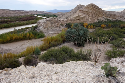
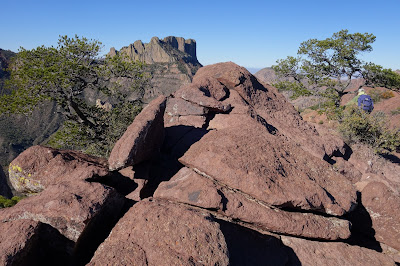
We spent last night at the Rio Grande Village campground. It was a chilly night, but soon warmed up. We headed for Boquillas Canyon is at the SE corner of Big Bend near Rio Grande Village. Here the Rio Grande River forms the USA-Mexico border andpasses through the Sierra del Carmen mountains.
Western entrance to the Boquillas Canyon
Ed taking photos of a creosote bush.
Close up of creosote bush
Desert marigoldsMexican men from Boquillas del Carmen on the Mexican side of the river making walking sticks from sotol to sell to tourists.
These sticks and other items were left on the US side of the river
All items were marked with a price and there was an honesty jar to to leave money.
About 300 meters further down the trail we passed the "singing cowboy" standing near the river and doing a rendition of Feliz Navidad. There was an empty jar to leave a gratuity. As we walked back from the entrance to the canyon, he had moved to the Mexican side of the river, but was still singing. A few minutes later we understood why he'd moved, as three US Border Patrol guards walked along the trail toward the canyon entrance. Apparently, a lookout on the Mexican side had tipped off our crooner. The guards did not confiscate the tourist trinkets or honesty jars, despite signs that it was illegal to purchase these goods on the US side. We got the impression the border patrol was just staking out its territory, had bigger fish to fry and played a relatively friendly a cat-and-mouse game with the Mexican entrepreneurs.There is a remote border crossing to Boquillas del Carmen where we could have taken a row-boat ferry across the river and then a truck, horse or donkey ride to the town. Instead, we opted to visit the site of an old resort with hot pools.
Introduced palms at ruins of the old resort.
Native Americans drew on some of the cliffs near the river.
We walked ca. 1/3 of a mile to the 105°F hot-water springs next to the Rio Grande River.
For the trip back to the car, we walked at the top of the cliffs. Here we're looking down at the same palms we saw at the beginning of the walk to the hot pools.
We drove to Daniel's Ranch near to Rio Grande Village. Cottonwood trees.
From there we took the Hot Springs Trail (it eventually gets to the same springs to which we just drove the car) along the river. It climbs several hundred feet and then goes along the cliffs above the river.
Rio Grande from the cliffs
Looking up river toward the Hot Springs.Looking down river toward Boquillas del Carmen.
There are many varieties of prickly pear cactus (Opuntia spp). This one has no needles.
Our campsite at Rio Grande Village just before we packed up to go to Cottonwood Campground at Castolon.
Chihuahuan Desert.
Chisos Mountains in the center of the park. This is a volcanic island surrounded by the Chihuahuan Desert
Dugout Wells, early ranch ruins, on the way to Panther Junction
Cactus skeleton
Many of the prickly pear cacti were turning a beautiful purple, but that seemed to mean they were dying.
Mistletoe
Sam Nail ranch. Remnants of old pecan and fig trees, two windmills and the wall of an adobe house.
Next was the Homer Wilson ranch
The track to the ranch went past sotols.
We think this could be Emory Peak
Woodpeckers were at work on the old house.Santa Elena canyon in SE corner of the park from Sotol Vista.
We walked to the Burro Mesa Pour-off. A cholla cactus.
The path to the pour-off went along this twisting wash
Fixing lunch back at the car.
Cerro Castellon mountain
Santa Elena Canyon on the Rio Grande is about 7 miles long and is in the western part of Big Bend NP. Water levels have become so low that trips down the river often use canoes rather than rafts.
Santa Elena Canyon
Santa Elena Canyon from inside the canyon
Looking out from the downstream end of Santa Elena Canyon
A group of about 18 javelinas (collared peccaries) came through our campsite at Cottonwood.
Day 44 14 December 2015 Cottonwood Campground to Chisos Basin (46 miles)
Cottonwood Campground - We shared the campground with only five other groups. Apparently the lack of flush toilets put off many campers. It was another chilly night. All our extra pads, quilts, sleeping bags, long underwear and socks came in handy.
After breakfast we headed back toward Panther Junction. We stopped at Castellan to view the ruins of the former farming community and view Santa Elena Canyon.
3293-foot Cerro Castellan
Tuff Canyon
Just before Panther Junction we took the road up to the Chisos Basin Campground. The campground is at 5400 feet elevation, but as its name suggests, it is in a basin surrounded by higher peaks.
Our campsite at Chisos Basin Campground
7325-foot Casa Grande, SE of the campground
We took the 4.4-mile round trip to the window pour-off
after reading up on what to do when we encounter a lion or bear.
The path descends from the campground at 5400 feet to the pour-off at 4600 feet.The last part of the trail follows the stream bed carved into the rock.
The window.
Water going over the pour-off falls several hundred feet.
Stream bed on the way back to the campground
Lichens
Casa Grande from the Window Trail.
This scat is probably from a caoti that had been eating madrone berries.
Cactus wren at the campground
The Carmen deer is a subspecies of white-tailed deer found only in the Chisos Mountains of the Big Bend.
Sunset from the the Window Lookout Trail near the Chisos Mountains Lodge
The night sky was glorious, even with light pollution from the ablution block at the campground. You can easily see the constellation Orion on the right.
The Lost Mine Trail is a 4.8 mile round trip on the East side of the Chisos Mountains
After one mile the trail comes out onto a col with rewarding views
Casa Grande on the right and Toll Mountain on the left
Continuing up the views only get better
Now the road and Chisos Basin are visible, with the western part of the park in the distance.
South Rim of the Chisos Mountains toward the left of the photo. A bit further to the left Dominguez Mountain and Elephant's Tusk.
Near the end of the Lost Mine Trail. Elephant Tusk in the distance.
Oak trees near the beginning of the Lost Mine Trail
In the late afternoon we went for a walk in the area to the west of Casa Grande Peak.
Roadrunner on a path near the Ranger Station
Day 46 16 December 2015 Chisos Basin to Fort Davis TX (192 miles)
We woke up to a frozen water tap and a frost. By 8am the temperature was up to 32°F (0°C).
Washing up and packing to leave Chisos Basin and Big Bend
Ocotillo
We left the park via Study Butte / Terlingua. The landscape became more like the Badlands in South Dakota.
We continued to follow the Rio Grande, going through Big Bend Ranch State Park.
Road and river looking southeast
Hills about half way through Big Bend Ranch State Park
Fort Leaton State Historic Site is just before Presidio TX. It was a trading post that operated from 1848-1884 on the Old Chihuahua Trail.
Exterior of fortThis was the main dining room
Corrals and yards for the fort.
Rooms used for Leaton's employees.
Church in Shafter TX, just north of Presidio.
Pushing on toward Marfa
Border patrol control point. We're starting to get used to these and breezed through.
Presidio County courthouse in Marfa Texas. The population has been declining from a high of over 4000 in about 1930 and is currently about 1800. We'd hoped to find accommodation here, but couldn't find anything in the middle ground between run-down motels on Route 90 with iron bars on all the windows and boutique hotels in the CBD such as El Paisano Hotel. That seemed typical of the town which hosts art festivals and the Chianti Foundation, yet where 1 in 5 is living below the poverty line.
.oOo.


No comments:
Post a Comment